To ensure you’re receiving the most up-to-date and accurate information, please choose the correct agency from the homepage. The DHEC website is no longer being updated and will be permanently unavailable Dec. 31, 2024.
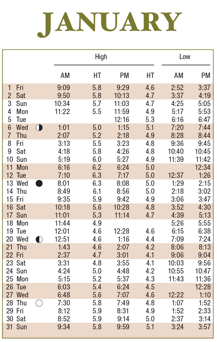
Download a convenient desk version of the 2021 Tide Chart
Quick Views:
Note: All times indicated are for Charleston - Custom House. Tide heights relative to Mean Lower Low Water.
Tide data provided courtesy of the National Oceanic and Atmospheric Administration (NOAA)
Location Correction Information
| Location |
High Tide |
|---|---|
| Cherry Grove | +10 min. |
| Myrtle Beach, Springmaid Pier | -26 min. |
| Socastee Bridge ICWW | +3 hr. 26 min. |
| Garden City Pier | -26 min. |
| Litchfield Beach Bridge | +44 min. |
| Pawleys Island Pier | -24 min. |
| Winyah Bay Entrance | -21 min. |
| Georgetown, Sampit River | +1 hr. 25 min. |
| Isle of Palms Pier | -25 min. |
| Cooper River, Goose Creek Entrance | +43 min. |
| Ashley River, Magnolia Gardens | +1 hr. 02 min. |
| Stono River, Limehouse Bridge | +1 hr. 43 min. |
| Edisto Beach (Approximate) | -25 min. |
| Skull Creek, North Entrance (Approximate) | +22 min. |
| Beaufort, (Approximate) | +1 hr. 04 min. |
| Bluffton, River (Approximate) | +1 hr. |
Distribution Locations - Limited to Supply On-Hand
The 2021 Tide Tables Posters are now available! Quantities will be limited to supply on-hand at select DHEC office locations. Please call ahead to check availability and office hours.
Myrtle Beach/Grand Strand
927 Shine Ave.
Myrtle Beach, SC 29577
Tel: (843) 238-4528
Charleston
1362 McMillan Ave.
Suite 400
Charleston, SC 29405
Tel: (843) 953-0200
Beaufort
104 Parker Drive
Beaufort, SC 29906
Tel: (843) 846-9400
Tide Charts are not intended for individual retail sale.
For all order inquiries, please contact Liz Hartje at hartjeen@dhec.sc.gov or 843-953-9237.