South Carolina’s beachfront jurisdictional area is made up of three beachfront critical areas. These beachfront critical areas are defined in South Carolina Code of Laws §48-39-10, and include:
- Beaches - those lands subject to periodic inundation by tidal and wave action so that no nonlittoral vegetation is established.
- Beach/Dune System - all land from the mean high-water mark of the Atlantic Ocean landward to the 40 year setback line described in §48–39–280.
- Coastal Waters - the navigable waters of the United States subject to the ebb and flood of the tide and which are saline waters, shoreward to their mean high-water mark.
Proposed activities within any of the state’s beachfront critical areas should be coordinated with DHEC OCRM to determine if notification or an individual permit application is necessary. Staff are available to assist citizens in understanding the beachfront jurisdictional lines and the authorization process associated with specific property and specific activities within all of the beachfront critical areas.
Beachfront Jurisdictional Lines
South Carolina Code of Laws §48-39-280 requires DHEC OCRM to establish and periodically review two beachfront jurisdictional lines - the baseline and the setback line - which delineate the extent of the state’s direct permitting authority for activities proposed within the beach/dune system critical area. The baseline is the more seaward (towards the ocean) line, while the setback line is the landward (towards the land) line. The jurisdictional lines enable DHEC OCRM to implement laws and regulations that support the state's beachfront management goals and protect vulnerable shorelines and natural ecosystems within this critical area.
The jurisdictional lines create a state jurisdictional area for the beach/dune system critical area, where activities associated with habitable structures, pools, erosion control structures, renourishment, landscaping, fencing, decks, service lines, and others are reviewed through authorization and permitting processes. Repairs, reconstruction, and new construction are allowed under certain conditions and with authorization by DHEC OCRM.
It is important to be aware that in addition to the beach/dune system critical area, there are two other beachfront critical areas in South Carolina, beaches and coastal waters, in which DHEC OCRM has authority to review activities. Please be aware that there may be critical areas landward of the jurisdictional setback line that may also require authorization and coordination with DHEC OCRM. For questions, please reach out to DHEC OCRM’s Beachfront Management section at (843) 953-0200, or visit the Project Manager Finder Application to find contact information for DHEC OCRM project managers by geographic area.
Jurisdictional Lines Review Process
South Carolina law requires DHEC OCRM to establish and review the position of the beachfront jurisdictional lines every seven (7) to ten (10) years. The average annual erosion rate for all oceanfront land that is developed or potentially could be developed is also reviewed during this time frame.
Using historical and present-day shoreline and beach profile information, DHEC OCRM designates a baseline and setback line along the coast. The baseline is typically placed at the crest of the primary oceanfront sand dune (that is the dune immediately adjacent to the ocean) while the setback line is demarcated landward of the baseline. The setback line's distance from the baseline varies along the coast. It is determined by the calculated long-term annual erosion rate in that particular area. The minimum setback is 20 feet. For additional information on the technical process associated with establishing the jurisdictional lines, please refer to the video below.
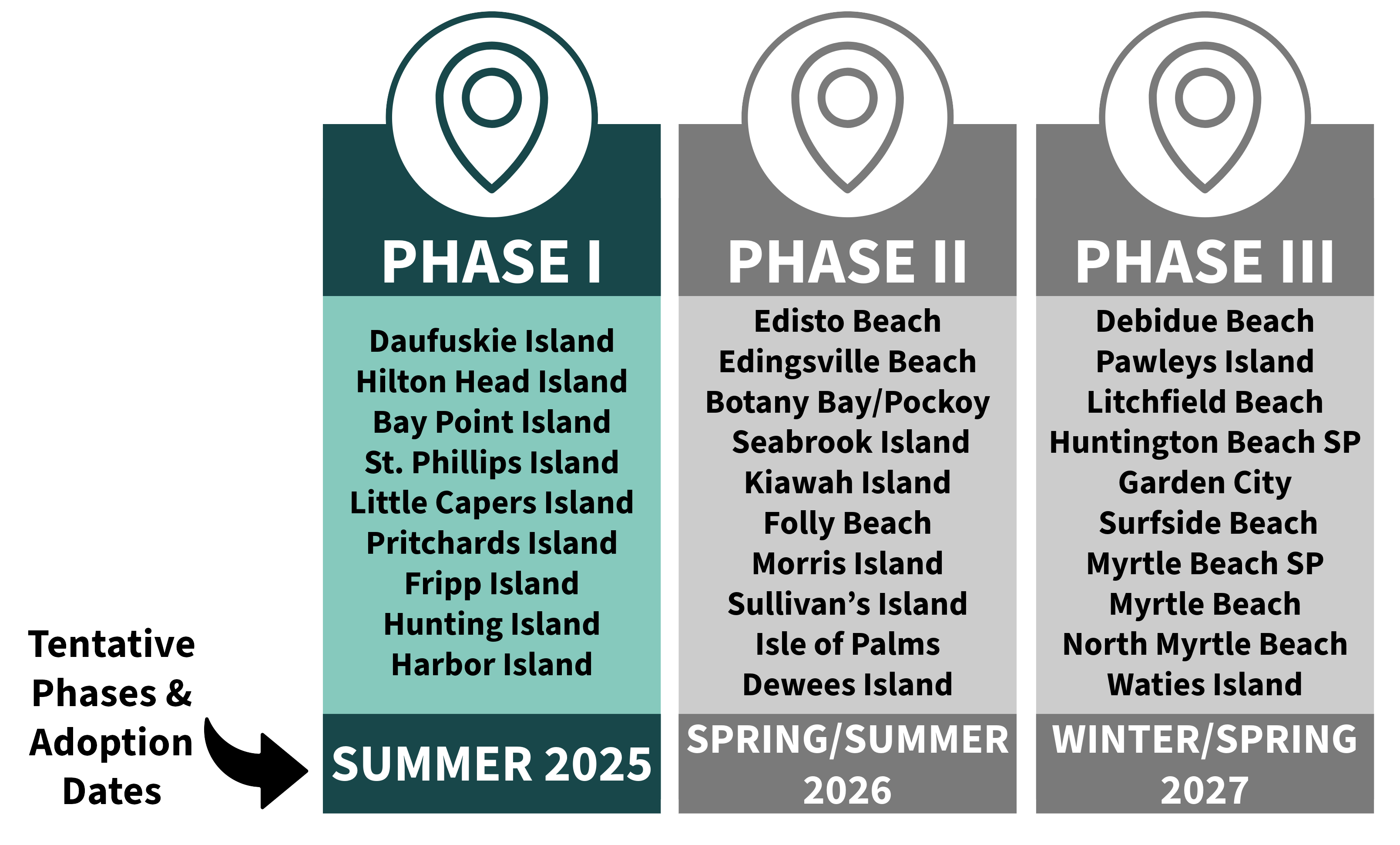
Upcoming Jurisdictional Lines Review - Beginning 2024
The next jurisdictional lines review cycle will begin in 2024. DHEC OCRM’s tentative schedule for line establishment and adoption is below. This line review will be a phased effort that will occur between 2024 and 2027. There will be many opportunities for public education and engagement. Please refer to this webpage for the latest updates and information.
Public Education and Engagement
To assist property owners, local governments, and other interested parties in understanding the state’s beachfront critical areas and jurisdictions, DHEC OCRM will be developing a Beachfront Educational Campaign. This effort will utilize a variety of methods to reach a broad and diverse audience including digital products, print materials, social media, as well as in-person and virtual information sharing opportunities. In-person and virtual town hall-style informational meetings are listed below.
Please be aware that no new lines are available at this time. These meetings are only for information on the process.
Wednesday, May 8th from 4:30-6:30pm
Town of Hilton Head Island Hall
1 Town Center Ct Hilton Head Island, SC
Thursday, May 16th from 4:30-6:30pm
St. Helena Branch Library
6355 Jonathan Francis Sr Rd. St Helena Island, SC
Virtual Option
May 22nd 12:00pm-2:00pm
Link to Register
Beachfront Jurisdictional Lines Viewer
For Property Owners
To assist property owners in understanding the location of the jurisdictional lines on their property or an area in which they are interested, DHEC OCRM developed the Beachfront Jurisdictional Lines Viewer. This viewer illustrates the approximate locations of the jurisdictional baseline and setback line statewide. Please note that to determine the exact position of jurisdictional lines for a given property, coordinates must be obtained by downloading data from the Beachfront Jurisdictional Lines Viewer and a property-specific survey must be performed. Coordinates can also be obtained by calling DHEC OCRM at (843) 953-0200.
For Land Surveyors
Survey packets with coordinates are available through DHEC OCRM’s Beachfront Jurisdictional Lines Viewer. There is a single survey packet for each beach, which contains the coordinates for the baseline and setback lines. This survey packet also contains a pdf file of the beachfront survey monuments that are maintained by DHEC OCRM. Please be aware that the coordinates provided in the spreadsheets may not be in order north to south; users should download and utilize the full spreadsheet to ensure that no coordinates along the baseline or setback line are missed.
Coordinate system
The baseline and setback lines are in State Plane NAD83 (2011).
The beachfront survey monuments are in State Plane NAD83 (2011) International feet.
Contact
DHEC OCRM staff are available to answer questions about the beachfront jurisdictional lines. Please contact DHEC OCRM at (843) 953-0200.
Resources
- Beachfront Jurisdiction Line Viewer (includes survey packets with coordinates, line reports, shoreline change rates, and GIS data)
- The South Carolina Coastal Zone Management Program - Statutes, Regulations and Enforceable Policies